
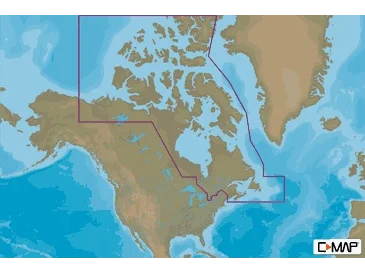

C-MAP NA-M021 Max N+ microSD
Canada North And East
Model: NA-Y021
- Card Format: SD/MicroSD
- Full-Featured Vector Charts – Provide boaters with the accurate,up-to-date vector chart detail including Depth Areas and Contours, SpotSoundings, NavAids, Light Sectors, Wrecks/Obstructions, Small CraftFacilities and more
- Harbor & Approach Details – Lets boaters approach any harbor and inletwith confidence – the perfect conclusion to a long voyage, sailing adventureor exciting day of bluewater fishing
- Tides & Currents – Presents the time, water level and direction of tideswith Tide Level graphs and indicates predicted current time, direction andstrength of currents with Current Flow graphs and colored arrows. Thisinformation is vital for navigation and fishing
- C-Marina Port Database – Provides useful, categorized information forcruisers, fishermen and sailors – including Port Layout and Facilities,Operating Hours, Accessibility, Phone/Email Contact Info and more
- Detailed Marina Port Plans – Docking in an unfamiliar port is noproblem, when you have precise layouts of thousands of marinas, includingslip spaces, restricted areas, and other valuable navigation information
- Dynamic Raster – Traditional paper chart” look with unique ability to
WARNING: Cancer and Reproductive Harm – www.P65Warnings.ca.gov.
